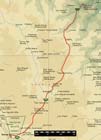
Our route on Day 5.
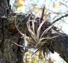
A bromeliad growing in a pine (Pinus lawsoni) tree.
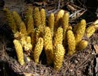
Unknown plant found in the mesic pine-oak forest about 80 km north of Oaxaca.
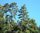
Mature Pinus ayacahuite var. ayacahuite growing near Puerta del Sol.
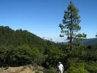
Bob, Pinus patula, and the view north into Veracruz from the Continental Divide.
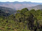
Pinus patula forest and view south from south of the high pass.
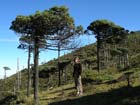
Bonnie in the pygmy forest at the highest pass on Highway 175.

Laundry day in Valle Nacional.
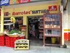
A visit to the supermarket in Valle Nacional.

Conifer-Hunting in Mexico
Day 5: Tuesday, February 8
We rose early enough to have a light breakfast at 0800. As usual the day dawned clear and bright, cool but with the promise of heat as the sun climbed higher. Bob and I retrieved the car and at the hotel, as I screeched to a halt in the street, blocking traffic, Bob and Bonnie threw the packs in the trunk and we raced off into Oaxaca's rush hour traffic. We stopped at a supermarket on the way out of town to load up on a few necessities, and then headed north on Highway 175 into the Sierra Norte.
The highway immediately began to climb and in a few kilometers we had left nearly all signs of human habitation, except for an occasional isolated farmhouse or roadside store. Even these nearly disappeared as we went further into the mountains. We climbed first through something like chaparral, and then Pinus lawsonii appeared in the brush, clinging to mountainsides above the Valley of Oaxaca, and we had a couple of stops to confirm its identity and ponder it a bit. As the road climbed, it was soon joined by Pinus pseudostrobus var. apulcensis, and for many kilometers these two pines largely defined the forest. The Pinus pseudostrobus var. apulcensis forest was quite magnificent, the trees growing tall and arching over the road, sometimes with a little Abies religiosa growing as an isolated tree. This forest accompanied us as far as the first pass and beyond, I think to beyond the colorful little village of Ixtlan de Juarez, where we filled the tank (150 pesos).
Beyond this point we began to move sensibly into the area of influence of the moist Gulf air masses, and the pine forest changed to one dominated by Pinus patula with some Pinus oocarpa var. trifoliata and still a bit of Pinus pseudostrobus var. apulcensis. The latter was quite impressive; in one place I found a tree with needles ca. 40 cm long. At that spot we also saw some Pinus leiophylla subsp. leiophylla, and the Abies religiosa remained a minor component of the forest.
At about the best development of this forest type we reached the roadhouse of Puerta del Sol where we turned left to see a formal forest reserve and have a little lunch. On this drive we picked up a local couple and gave them a ride as far as the village of San Pedro Yolox, a very small village in a very deep canyon. Here we had a rather strange experience. The little village was celebrating Carnaval in the middle of the afternoon, today being after all Mardi Gras, and their little parade was wending its way up the only street in the village, which we were coming down. Now in reaching this village we had dropped utterly out of the forest so I was happy at this point to leave the old couple to continue their journey while we retreated to the mountains. Actually doing this, though, required a considerable explanation to the old couple and a small group of villagers. We wanted to tell them that we had come to see their forest, not to gawk at their Mardi Gras, and that we would be happy to leave the old couple here and retrace our steps; but the complexities of this explanation lay beyond our abilities in the Spanish language. It was an awkward time, but after a while all was made reasonably clear, we made our farewells, and we returned to the highway, where we continued into the north.
The road kept climbing gradually through more mesic forests, now comprised of Pinus patula, Pinus hartwegii, Pinus chiapensis, possible Abies guatemalensis (not confirmed), oak, and sweet gum. A final climb took us to 2950 m, where we reached the continental divide between the moist Caribbean and the dry Pacific. At this point we were in what locally passes for the alpine zone. Ground covers included species of Gaultheria and a probable Vaccinium, and a small shrub looking very much like heather, as well as various cushion and low rosette herbs. Snags showed that at some time in the past the forest was more continuous, but now the trees on the exposed windward (northern) slope consisted of Pinus hartwegii a few meters tall with all their foliage and branches in a top pom-pom. Just in the lee of the ridge, the ground cover changed to tall shrubs with few emergent, windswept Pinus ayacahuite var. ayacahuite. It was one of the most remarkable timberlines I have seen, and I am at a loss to explain the pom-pom growth form, quite unlike anything we saw in the timberline forests at Popo-Izta.
The valley to the north was filled with clouds that lay thousands of feet below us, but reached to the northern horizon. The day was wearing late and we knew we would have to hurry to reach our destination, Valle Nacional (the next town), by dark. So we drove off over the edge.
The road all day was paved but very steep and twisty, and the steepest and twistiest part of all lay in the next 50 kilometers, in which the road descended more than 2500 m, nearly to the level of the coastal plain. I know of no such precipitous road descent in North America (the famous Pike's Peak road, for instance, only climbs 2,054 meters). As soon as we started downward, the vegetation became very mesic, the only conifers a few Pinus chiapensis and Pinus patula and suspected Abies guatemalensis, and even these soon vanished to be replaced by dripping fern-clad cliffs, looming tree ferns, a net of lianas, giant oaks wrapped in epiphytes, and all the other trappings of a montane tropical rainforest--a cloud forest. By the time we had descended to 2000 m it was a true jungle.
Still the road wound downwards. We began to see small roadside houses every few kilometers, and bananas made their appearance in small plantations clinging to the steep escarpment. Finally, after what felt like a very long and tortuous drive, we reached Valle Nacional, on the banks of the Valle Nacional River, tributary to the Papaloapan River which empties into the Gulf of Mexico. The sky was hung with clouds, the humidity maximum, the temperature about 30 degrees. The piercing cries of hundreds of tropical birds came from the treetops, while the town below was quiet but for the roaring passage of a poorly muffled diesel every few minutes (one of the most ubiquitous sounds of Mexico). There was not a tourist in sight, nor evidence that they ever passed this way.
After a couple of inquiries we found the hotel, a concrete building with iron gates and within, concrete cubicles with iron doors. Still the beds were comfortable enough and the rooms very clean, so for 200 pesos we booked 2 rooms. We found a meal and a couple of beers at a little place with only two food options—"antojitos," which an old man was frying up on the street outside; and "pollo," which we chose, and which turned out to be an acceptable pan-fried chicken in red sauce, served with a plate of flour tortillas and bowls of white rice and black refried beans. This basic fare proved satisfactory, and soon after dinner we retired. After the day's driving, I was worn out, and slept like a log.
Continue to Day 6
go back to "Conifer Hunting in Mexico"


